Surveying and Mapping the Land
In order to divide our land from Troy and Phaedra's property we've performed a basic survey and we're now creating computer based scale maps of the new parcel and the surrounding land.
It took me a day or two to develop a workable scale inside the computer drawing program and to fully understand how survey bearings are notated. I settled on using millimeters since lengths on the original survey maps were written in decimal form -- IE 123.45 feet.
I set the scale to 1 mm = 10 feet or 1 foot = 0.1 mm.
All angles had to be transcribed from survey notations of degrees, minutes and seconds to their decimal equivilents.
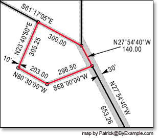 I started by using the measurements found on existing, professionally drafted survey maps of Troy and Phaedra's property to create a computer based version. Once the existing map was duplicated in my drawing program I began using our survey data to plot our survey points and draw the property lines in the computer version of the map.
One of our major goals in surveying the land we're purchasing is to determine the new parcel's size in acres. This will allow us to know the final price for the property.
The best way I know of to calculate the area of a polygon is to subdivide the space into right triangles. Then I used a wee bit of geometry and trigonometry to find the lengths of the sides on all the triangles. Once one knows the lengths of the triangles their individual areas (square footage) can be calculated by:
After that you just add up the square footage of each triangle to know the total area of the polygon (see diagram below).
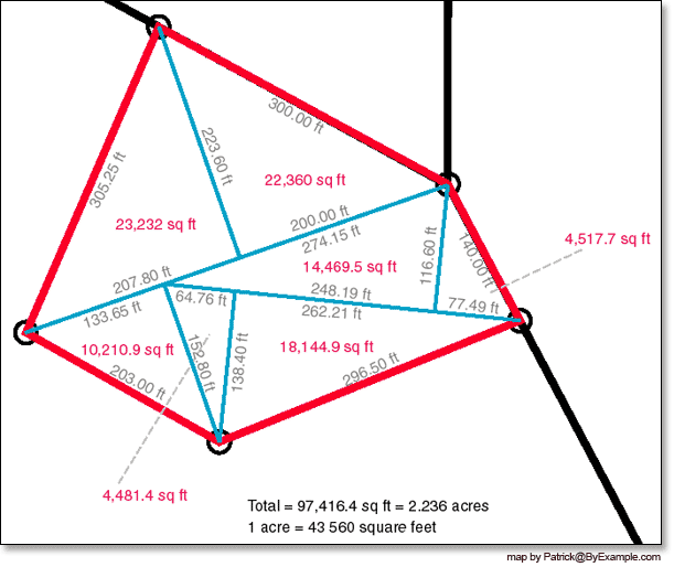
The total square footage of all the right triangles is 97,416.4 square feet.
1 acre = 43,560 square feet.
That means that our parcel of land is 2.236 acres.
Now that we know where our property line will fall, we are required to have an official survey performed before finalizing ownership. To read about the official survey, click here.